SUPER TIP! Autumn in Harrachov! Come to Harrachov for relaxation and nature!
Menu
SUPER TIP! Autumn in Harrachov! Come to Harrachov for relaxation and nature!
SUPER TIP! Autumn in Harrachov! Come to Harrachov for relaxation and nature!
SUPER TIP! Autumn in Harrachov! Come to Harrachov for relaxation and nature!
SUPER TIP! Autumn in Harrachov! Come to Harrachov for relaxation and nature!
SUPER TIP! Autumn in Harrachov! Come to Harrachov for relaxation and nature!
Get to know the surroundings of Harrachov at any age
harrachov
Booking
Harrachovka (large northern tour)
Trail description:
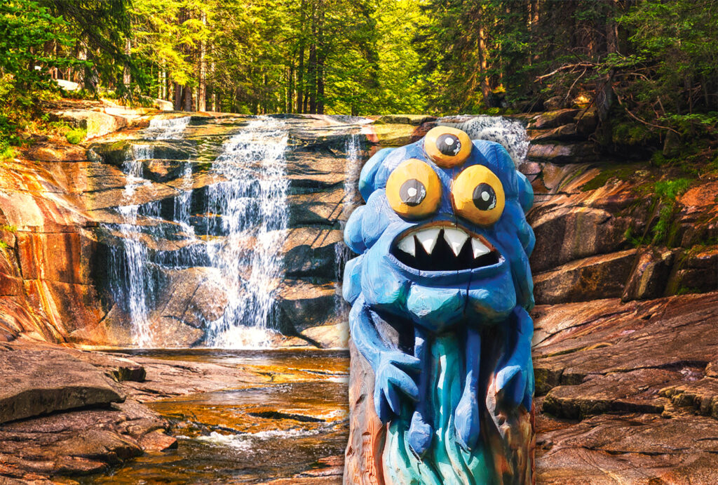
If we choose Norma as our starting point, the trail leads to Harrachov Road. We follow this road along the hillside to the north over the town using asphalt forest road up to Mumlava Waterfall (yellow-marked tourist trail). The trail turns back to the centre and leads along the blue-marked tourist trail to the alternative starting point at Šindelka (3,6 km). If we really decide for the large tour, we turn earlier at Hotel Lovecká Mumlava and follow a forest trail leading to an outdoor swimming pool. Going past Vinkl we get to large hotels Sklář and Svornost, and onwards to the territory of Sedmihorky . Passing through the housing estate V borovicích (Klondajk) we get to Norma again.
Start: supermarket NORMA x Expozice Šindelka
End: Exposition Šindelka x NORMA
Length/vertical distance: 6,0 km/124m the whole tour, Norma along Harrachovka –vdp. -2,7 km, vdp-across Sedmidomky – Norma 3,3 km
Difficulty: easy /middle
Use of Harrabus: no
Prams: yes
Track through Anenské Valley
Trail description:
The trail uses a local road leading through placid Anenský Valley. The starting point is the bottom station of Delta chair lift. Soon, we cross the stream of Bílá voda. Due to the regulation we cannot see rapids which have given the river its name. After the entry into the forest dividing both Harrachov valleys, we come to the spring of Sv. Jan. This spring provides slightly radioactive water. The local tradition says that this water is the most suitable material for production of teas. At the place where the formation level of the local road starts to rise and changes its direction to the right we leave the trail and along the fence of the water purification plant, we get to the Mumlava River. There, we shortly meet another nature trail Rybárna. If we do not choose it for our next walk, we recommend visiting the last of little ponds where Counts of Harrach kept fish and fish spawn. We leave the nature trail at the point where it crosses the river Mumlava and we continue further to the left into the area of standard ski tracks. Wide tracks with a perfect surface lead us back across the river Mumlava to the bottom station of the chair lift.
Start: the bottom station of Delta chair lift
End: the same place
Length/vertical distance: 3, 1 km/ 65 m
Difficulty: easy
Prams: yes
Use of Harrabus: no
Along Provincial Border
(addition of Vl.Fejkl incl. the name; the truth is that after the agreement of three aristocrats from the 17th century, the border between the Czech Kingdom and neighbouring Silesia was determined so that the territory between the present-day railroad and the Jizera River belonged to Silesia)
Trail description:
This trail is a prolongation of the previous trail. It means that we use one of the possible variant of standard ski tracks that continue as so called Raspberry trail leading to Mýto in Nový Svět. Here, the trail crosses the road and continues along the old bridge through Babí kout up the stream of Jizera. Afterwards, the trail follows the green-marked tourist trail and rises up to Mýtiny.
Start: the bottom station of the chair lift End: train stop Harrachov-Mýtiny
Length/vertical distance: 7,8km/320 m
Difficulty: difficult
Prams: no
Use of Harrabus: yes
Miner´s Trail (Hornická)
Trail description:
The trail starts at Sporthotel Rýžoviště and rises up the western slope of Ptačinec following the yellow-marked tourist trail. After entering the forest the trail passes several mining relics (extraction of barite, fluorite and galenite). After that, it goes down to Mumlava Waterfall. The trail remains on the left side of the river and continues up to the area of the hinterland of the former mine, today functioning as Mining Museum, and further to Exposition Šindelka.
Start: guest house Diana
End: Norma
Length/vertical distance: 3, 7 km/92 m
Difficulty: easy
Prams: partly
Use of Harrabus: yes
Standard FIS tracks
Trail description:
Two standard FIS ski tracks, each 7, 5 km long, have several cross-connecting legs. Wide ski tracks offer a wide range of variations.
Start: the bottom station of the chair lift
End: the bottom station of the chair lift
Length/vertical distance: 7, 5 km
Difficulty: middle
Prams: partly
Use of Harrabus: yes
To Deskový Waterfall
Trail description:
Although this trail is one-way only, it offers a chill-out trip along the Kamenice River ended by cascades of Deskový Waterfall. There are several splash dams on the trail built in order to moderate spring floods from melting snow. They can be used as an especial rest point at icily cold water.
Start: supermarket NORMA
End: supermarket NORMA
Length/vertical distance: 5,3 km/220 m
Difficulty: middle
Prams: partly
Bee´s Trail
Trail description:
The first information board of the nature trail is situated close to the bus station at the beginning of the valley of Rýžoviště Settlement. The first part of the trail runs through this valley and follows the stream of the Ryzí Creek. The trail leaves the creek near Lesní zátiší Cottage, then, it shortly follows the same way back and afterwards, it leads up along the flank of Ptačinec. Thanks to a steep terrain, the other side of the Šerý Gully, which flows through the valley below our legs, has been one of the places considered for the construction of a ski jump. Almost under the mountaintop of the southern spur of Ptačinec, the trail turns down into the valley. At first, we lose altitude slowly, and then, we descend quite rapidly right to the loop of Harrabus and back to the Ryzí Creek. Along the whole trail, there are educational boards supported by illustrations of the Giant Mountains´ flora and evolutional types of beehives that will guide you through the life of bees and bumblebees, and also through the universal use of bee products.
Start: near the bus station
End: Harrabus stop next to Fit and Fun Hotel Rýžoviště
Length/vertical distance: 3 km/135m
Difficulty: middle
Prams: no
use of Harrabus: yes
With the fox to Mumlava Waterfall
Trail description:
You can start either at Harrabus station or at the place where the blue-marked tourist trail crosses the city ring road. Soon, we leave the marked tourist trail and we continue to the right side, where we encounter a stage offering a range of rather locomotive attractions for children. A pleasant walk through the forest turns into a mountain path along Mumlava riverbed on the other side of the river. From this place, we get amazing views of the wild river. Then, we reach the top of our trip - the amazing view of the mightiest Czech waterfall Mumlava. Below the waterfall, we cross the Mumlava River again and continue along the road using the blue-marked tourist trail for our return.
Start: Exposition Šindelka
End: the same place
Length/vertical distance: 2, 1 km/85 m
Difficulty: easy
Prams: no
Use of Harrabus: yes
Nature Trail Rybárna
Trail description:
The starting point of the nature trail with a range of information boards concerning description of the place, the history and the nature of Harrachov and its surroundings, is at the entry into the area of the former Folly of the Count of Harrach that served as a Professional School of Forestry for many years. It continues into the area of a former fishery – another contribution of the family which has given the town its name. The trail offers a lot of opportunities to relax. It is a pleasant walk passable even with a pram bar a short part where the trail leaves the Mumlava River. Again, the nature trail ends near the area of the Folly of the Count of Harrach.
Start: the area of the Folly of the Count of Harrach
End: the area of the Folly of the Count of Harrach
Length/vertical distance: 1,3 km/ 28 m
Difficulty: easy
Prams: partly
Use of Harrabus: no
Special offer

Special offer

SUPER TIP! Autumn in Harrachov! Come to Harrachov for relaxation and nature!